Aton Provides Exploration Update At Abu Marawat Concession; New Exploration Target Identified
Vancouver, April 4, 2017: Aton Resources Inc. (AAN: TSX-V) (“Aton” or the “Company”) is pleased to provide investors with an update on the exploration activities currently underway at the Company’s 100% owned Abu Marawat concession (“Abu Marawat” or the “Concession”), located in the Eastern Desert of Egypt.
Highlights:
- The Company has completed 12 holes of the originally planned 14 hole, 2,300 metre diamond drill program at Hamama West (see news release dated February 21, 2017).
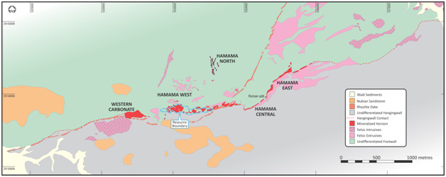
- Crone Geophysics have commenced a ground and downhole electromagnetic (EM) survey of the 6-km long prospective horizon (or the hanging wall contact) at Hamama (see Figure 1).
- Utilizing LANDSAT-8 and ASTER regional remote sensing data, 92 spectral targets have been identified within the 738km2 Abu Marawat.
- Regional target identification program has begun and targets will be ranked, based on field inspections and remote sensing and spectral data, according to their level of prospectivity.
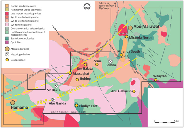
- Identification program has already generated a new exploration target named Waayrah. Field crews have identified a gossan with extensive secondary zinc and copper mineralization that is up to 12m thick and exposed over a strike length of at least 450m. (see Figure 2).
Figure 1. 6-km long prospective horizon (or the hanging wall contact) at Hamama
“Since announcing the resource estimate for Hamama West this past January, our exploration efforts have been directed towards resource expansion and the identification of new, high priority exploration targets,” said Mark Campbell, President and CEO of Aton. “We believe there is tremendous potential to grow resources at Hamama West and most of the drill holes in this program are designed to do that. Concurrently, we launched a geophysical program to identify other drilling targets in and around the Hamama area. Further, on a regional scale, the remote sensing and spectral data are helping us to identify and zero in on high priority exploration targets. Historically, very little regional exploration work has been conducted and we believe that our regional target identification program could result in a new, significant discovery.”
Figure 2. Abu Marawat concession area
Hamama area exploration
The Company has drilled 12 holes of the originally planned 14 hole, 2,300 metre diamond drill program (see news release dated February 21, 2017). Drilling to date has focused primarily on testing the strike and down-dip extensions of the mineralization at Hamama West, with the goal of building resources. Hamama West hosts an Inferred Mineral Resource of 341,000 ounces’ gold equivalent (“AuEq”) and an Indicated Mineral Resource of 137,000 ounces AuEq (see news release dated January 24, 2017). In addition, two new trenches were excavated and sampled, in accordance with NI 43-101, to test mineralization at the SW extension of Hamama West, which was not included in the mineral resource estimate.
Concurrently, Crone Geophysics have commenced a ground and downhole electromagnetic (EM) survey of the 6-km long prospective horizon (or the hanging wall contact) at Hamama (see Figure 1), with the aim of identifying buried conductive bodies, potentially related to massive sulphide style mineralization. Downhole EM surveying will be undertaken at Hamama West, Hamama Central, Hamama East, and the Western Carbonate.
Regional exploration
As part of a regional target identification program, Dr. Michael Brown (Mappa Mundi Surveys) was contracted in the second half of 2016 to complete a remote sensing and spectral processing survey of Abu Marawat. Utilizing LANDSAT-8 and ASTER regional remote sensing data, Dr. Brown identified 92 spectral targets within the 738km2 Abu Marawat. In addition, high resolution multispectral WorldView-3 (WV-3) satellite imagery was acquired during February, 2017, over Hamama and the areas between Abu Marawat, Miranda, and Semna, which will also aid in identifying regional targets.
Preliminary field inspections of some of the regional targets, including the Sir Bakis, Semna, Abu Garida, Abu Gaharish, Zeno, Bohlog and Massaghat prospects, have been completed (see Figure 2) and all other known targets within Abu Marawat will be investigated over the coming weeks. Following the completion of field inspections, combined with the remote sensing and spectral data, targets will be ranked and further investigated according to their level of prospectivity.
The regional exploration program has already generated a new exploration target named Waayrah. Field crews have identified a gossan with extensive secondary zinc and copper mineralization that is up to 12m thick and exposed over a strike length of at least 450m. (see Figure 2). In addition, preliminary evaluation of the WV-3 imagery, covering the area to the east of the Semna Mine and south to the Waayrah prospect, has led to the discovery of ancient and modern workings in an area not previously investigated. This further demonstrates the district-scale potential of Abu Marawat.
About the Hamama deposit
The Hamama deposit (“Hamama”) is located at the western end of the 40-km long gold trend at the Abu Marawat Concession and is comprised of three zones, Hamama West, Hamama Central and Hamama East. The mineralized horizon at Hamama has a strike length of approximately 3-km and mapping indicates that the prospective horizon (or the hanging wall contact) may be over 6-km long. Other potentially mineralized horizons, separate from the main mineralized horizon, have also been mapped in the general Hamama area.
About Aton Resources Inc.
Aton Resources Inc. (AAN: TSX-V) is focused on its 100% owned Abu Marawat Concession (“Abu Marawat”), located in Egypt’s Arabian-Nubian Shield, approximately 200-km north of Centamin’s Sukari gold mine. Aton has identified a 40-km long gold trend at Abu Marawat, anchored by the Hamama deposit in the west and the Abu Marawat deposit in the east. In addition to the Hamama and Abu Marawat deposits, the trend contains numerous gold exploration targets, including three historic gold mines. Abu Marawat is over 738km2 in size and is located in an area of excellent infrastructure, a four-lane highway, a 220kV power line, and a water pipeline are in close proximity.
Qualified Person
The technical information contained in this News Release was prepared by Roderick Cavaney BSc, MSc (hons), MSc (Mining & Exploration Geology), FAusIMM, SEG, GSA, SME, Vice President, Exploration, of Aton Resources Inc. Mr. Cavaney is a qualified person (QP) under National Instrument 43-101 Standards of Disclosure for Mineral Projects.
For further information regarding Aton Resources Inc., please visit us at www.atonresources.com or contact:
Mark Campbell
President and Chief Executive Officer
Tel: +1-936-689-2589
Email: mcampbell@atonresources.com
Blaine Monaghan
Vice President, Investor Relations
Tel: +1 (604) 331-5092
Email: ir@atonresources.com
Note Regarding Forward-Looking Statements
Some of the statements contained in this release are forward-looking statements. Since forward- looking statements address future events and conditions; by their very nature they involve inherent risks and uncertainties. Actual results in each case could differ materially from those currently anticipated in such statements.
Neither TSX Venture Exchange nor its Regulation Services Provider (as that term is defined in policies of the TSX Venture Exchange) accepts responsibility for the adequacy or accuracy of this release.